|
|
Starting from Monterey Peninsula Airport, take Highway 68 to Highway One north.
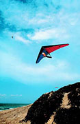  The highway initially runs between high sand dunes and the communities of Seaside and Sand City. These neighboring towns are a good place to stock up on snacks, sunscreen or maps, as they possess dozens of shops of all sizes. A Class A, paved, recreation trail for biking and jogging crests dunes and parallels the road — it runs another 15 miles north to Castroville. Look for kite-fliers and hang gliders all along this stretch; if you join them, be aware of signs noting the restoration of fragile plants to this windblown habitat. The highway initially runs between high sand dunes and the communities of Seaside and Sand City. These neighboring towns are a good place to stock up on snacks, sunscreen or maps, as they possess dozens of shops of all sizes. A Class A, paved, recreation trail for biking and jogging crests dunes and parallels the road — it runs another 15 miles north to Castroville. Look for kite-fliers and hang gliders all along this stretch; if you join them, be aware of signs noting the restoration of fragile plants to this windblown habitat.
- For an opportunity to walk out into the dunes safely, exit Highway One at Reservation Road; turn left under the highway and go straight to the Marina State Beach. A wheelchair accessible boardwalk winds through Marina Dunes Natural Preserve.
Return to Reservation Road and follow it under Highway One to the bustling, practical little town of Marina; a good selection of restaurants, accommodations and shopping. Locke-Paddon Park (831-384-4636 for information) is one of the few original wetland wildlife preserves in North America, open to hikers and naturalists looking for several endangered species.
Return to Highway One northbound. In a few miles, take the easterly fork on Highway 156 to Castroville.
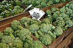 - 90% of America�s artichokes are grown within a few miles of the town that calls itself The Artichoke Capital of the World; Marilyn Monroe was crowned the first Artichoke Queen here in 1948, before she shot to stardom. Explore its main street, Cabrillo Road (Highway 183), which then connects back to Highway One northbound.
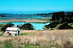
A sharp left turn at Potrero Road leads to Salinas River State Beach, a three-mile stretch of sand perfect for wildlife spotting, kite-flying and picnicking (though it is too rough for watersports or swimming). A gradual left turn at this intersection leads to Moss Landing Road and the hamlet of Moss Landing.
 Founded by Charlie Moss as a shipping point for locally produced salt, the sheltered harbor has grown into a nexus for fishing, boating, marine sightseeing tours (both whalewatching and exploring neighboring Elkhorn Slough), and, surprisingly, antiques. Several good restaurants, a b&b; and RV campground. (831-633-4501 for information)
Return to Highway One northbound, and make an immediate right onto Dolan Road, next to the huge PG&E; power station. At Elkhorn Road, turn left and continue several miles to the Elkhorn Slough National Estuarine Research Reserve.
 The Visitor Center (831-728-2822 for information) is located in the heart of the Slough, which is one of the nation�s rare estuary wildlife preserves. The Center offers guided tours on the weekends in addition to interpretive information and fascinating displays (including a vastly enlarged slice of mud, complete with worms!).
Continue on Elkhorn Road past Kirby Park. More water than land, Kirby Park is primarily a jumping off point for boating and fishing, but visitors with binoculars can spot many estuary birds and wildlife. After winding through low hills, Elkhorn Road joins County Road G12; continue straight towards Watsonville.
- Another important hub of produce distribution, particularly by rail, Watsonville is noted for strawberries and its Latino-accented home-town atmosphere, acquired in recent years thanks to the many Mexican-born farm-workers who live and work nearby.
Just after the railroad tracks, turn right on Aromas Road (County Road G11), and follow it into Aromas. One of the smallest towns in Monterey County, Aromas retains its village atmosphere despite the recent arrival of Silicon Valley refugees.
Leave town on Carpenteria Road, continuing on it to a T-junction with San Juan Road (County Road G11) where you turn left. Continue on San Juan Road to Highway 101.
- For a visit to San Juan Bautista and its famous mission, go north on 101 to the exit for Highway 156. The town of San Juan Bautista retains a pleasing compound of historic building, centered on the handsome adobe church (open to the public daily) founded by Father Junipero Serra. Its quaint main street has many caf�s and antique shops.
Return to Highway 101. Here you can go north to San Jose and San Francisco, or turn south to Salinas.
- The county seat of Monterey, Salinas was incorporated in 1874. The city is a hub for the processing and shipping of hundreds of thousands of tons of vegetables every year, and now famous as the birthplace of John Steinbeck.
Highway 101 southbound runs directly through Salinas. Leave Highway 101 at Boronda Road; turn left across the highway, then right on North Main Street (County Road 183), a busy road lined here with large shopping malls, restaurants and cinemas. After a mile, on the left, is Sherwood Park, setting for the California Rodeo Grounds and Sherwood Hall.
Remain on North Main Street when it crosses Highway 101; it crosses under a railroad bridge and crosses Market Street. (Amtrak station on West Market Street.) Park in the lot on the left of the next corner, opposite Salinas Transit Center.
 Salinas�s most famous son, John Steinbeck (1902-1968), is celebrated in the modern National Steinbeck Center at the top of Main Street; the NSC has just opened a brand-new wing dedicated to agriculture of the "Valley of the World," as Steinbeck called the Salinas Valley while writing East of Eden. Salinas�s most famous son, John Steinbeck (1902-1968), is celebrated in the modern National Steinbeck Center at the top of Main Street; the NSC has just opened a brand-new wing dedicated to agriculture of the "Valley of the World," as Steinbeck called the Salinas Valley while writing East of Eden.
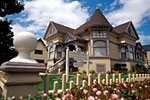 - The Steinbeck Birthplace, two blocks away on Central Avenue, is open to the public as a lunchtime caf� and bookshop. The town has many eateries, interesting shops, and a charming old-town style to its Main Street.
At this point, you can return to Monterey by continuing on Salinas Street to rejoin Main Street (follow signs — Main is one way at the end nearest the Steinbeck Center). Main becomes Highway 68/Monterey-Salinas Highway; Monterey is about 19 miles away. You can also rejoin Highway 101 southbound for San Luis Obispo and Los Angeles.
|
|
|
|